The volcano that erupted near Tonga (and I won’t pretend I can spell let alone pronounce its name) sent a shock wave racing around the world.
It was detected at weather stations across Australia as a sudden spike followed by sharp drop about half an hour afterwards, as in this screenshot from Rockhampton.
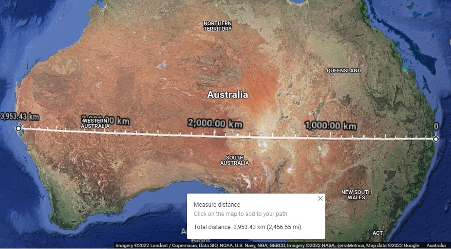
I used Google Maps to plot the course of the shock wave from the volcano across the widest part of Australia.
Showing just Australia:
I used BOM’s Weather Graphs of weather stations close to that line and found the times of the spikes and dips as the wave passed over.
It took roughly 3 hours and 24 minutes to cross the country. That’s 3,953km at about 1,160 kph.
Here’s a quick plot of the speed of the shock wave as it crossed Australia.
It’s not often you get to see such a phenomenon.


January 18, 2022 at 12:14 am
The shock wave seems to be travelling around the speed of sound. The reports say that the explosion was heard in Fiji 800km away.
January 18, 2022 at 6:03 am
Yes, the speed of sound is slower over land with obstacles like hills and trees, and at warmer temperatures such as in the Oz desert on a summer afternoon. The compression-decompression also gets slower, longer, and weaker with increasing distance.
January 20, 2022 at 10:04 am
Interestingly the shock wave was detected some 15 hrs later at three stations in Slovenia at 1900 UTC 15.01.2022 at 2.5 hPa (peak to peak) at a distance of 17,000 km (10,500 m) calculated at 1,133 km/h. The lack of attenuation is quite remarkable, likely as a result of half the distance travelled by the shockwave being over the northwestern Pacific and later over cold dense atmosphere of Siberia and then northern Russia.
January 20, 2022 at 11:07 am
In Australia the decompression was about 30 to 35 minutes after the compression peak. Was it similar in Slovenia?
January 22, 2022 at 2:38 pm
Yes indeed, it is very similar in all data I have sighted.
Here is a very interesting high resolution plot (0.2 hPa/mPa) from Chilterns, UK (practically the same distance as Slovenia) showing data for some nine hours after the arrival of the initial pressure wave at 1900 UTC. The atmospheric pressure disturbances clearly shown for a period of seven hours after the initial wave.
I have recalculated the great circle distance and route (shortest) for the northerly radiated wave to be further northerly through the northern Pacific, Bering Sea, Arctic Ocean and into Europe via the northern tip of Greenland a distance of 16,516 km, almost all over ocean at 1,101 km/h.
I suspect the 0130 UTC pressure anomaly was the arrival of the southerly radiated wave which had traveled the great circle (longest) via the southern Pacific, Antarctica and through most of Africa (via the antipodal of Tonga) a distance of 23,559 km at1,095 km/h.
January 22, 2022 at 4:01 pm
So 2.5 hPa was maintained.
I was somewhat surprised there were no interference pattern disturbances reported- there must have been some as the circular ripple expanded/travelled round the world and met directly opposite in the NH somewhere depending on speed. Or is my thought experiment just imagination?
January 22, 2022 at 9:50 pm
Your thought experiment is entirely logical and in fact one of the known laws of acoustics. The antipodal of Hunga Tonga-Hunga Ha’apai is located southern Algeria, where unfortunately no barometric station data is available to demonstrate the increase in wave amplitude (likely 5.0 hPa) as the shortest (Northern) and longest (Southern) waves met in phase at or near the antipodal. METAR Synop (Aviation) data is available for CSV download but it would appear barometric stations are all located in northern Algeria. What puzzles me is that this acoustic wave did not follow the inverse square law which states that an acoustic signal should attenuate at the rate of double the distance halve the amplitude, I suspect that the atmospheric curvature is able to contain the magnitude of the acoustic wave within the denser Tropospheric belt. I am aware that International Monitoring System (IMS) monitors acoustic volcanic signals (an offshoot of Nuclear weapons detonation monitoring), the Cape Verde in the Republic of Cabo Verde, station 1511 (Acoustic) is the closest station with a very similar latitude to southern Algeria and located just off the west cost of Africa.
I would expect the frequency range of the acoustic infra-sound signal to be about 0.5 Hz to 5 Hz (although it could be in the range of 0.01 Hz to 20 Hz), the frequency (wavelength) should equate to the time period you have stated as 30 to 35 minuets.
I suspect that a 1.25 hPa signal might be detected as the second pass of the original acoustic signal completes.
January 23, 2022 at 7:44 am
There were other waves picked up by some Australian stations (but not all) 11 to 12 hours later. Because it was not widely detected I discounted them as possibly local events such as mining blasts. I should have kept the data!
Thanks for your interest. I hope we hear more about this in coming months as world wide data is properly analysed by smarter blokes than me.