Archive for January, 2023

Extreme Weather Events 3: Sydney

January 29, 2023

Are extreme weather events showing up in Australia’s largest city?

Floods and bushfires might affect smaller areas, but droughts, heatwaves, and very heavy rainfall from large weather systems affect large areas. All of the above have occurred near Sydney in the past few years: surely there should be visible signs in temperature and rainfall.
First, rainfall.


In July and October 2022 flooding affected the western Sydney region again, with The Conversation of course saying “climate change is projected to bring far worse extreme rain events than in the past.”

For long term rainfall I look at Sydney’s longest rain records, at Observatory Hill and the Botanic Gardens. Figure 1 shows their location.


Figure 1: Central Sydney, courtesy of Google Maps

Observatory Hill rain records start in July 1858, but the original data ends in August 2020. I choose not to splice data from old and new gauges. Botanic Gardens start in 1885 but there is a large gap, with continuous data from late 1909 to the present. Figures 2 and 3 plot daily rainfall for each:


Figure 2: Observatory Hill daily rain

Figure 3: Botanic Gardens daily rain (1910 to 2022)

Long term means:


Figure 4: 10 year running means of rainfall at Observatory Hill and Botanic Gardens

Note that the means are similar until about 2010 when they start to diverge. Reasons might include changes to the sites. Rainfall was clearly higher in several previous decades.


Figure 5: 10 year running Standard Deviations

There was much greater variability in Sydney’s rainfall for most of the 50 years from 1950 to 2000. To show Standard Deviation relative to mean rainfall:


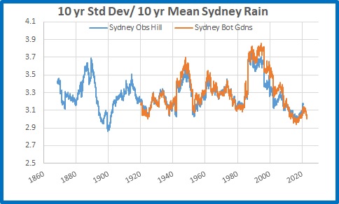
Figure 6: 10 year running Standard Deviations divided by 10 year means

Which shows there is little daily variability in rainfall in recent years, and both sites are comparable.


I will now analyse Botanic Gardens data in more detail.


Figure 7: Running 365 day means

2022 was the wettest year on record, followed by 1950.


Rainfall accumulated over several days is a factor in large scale riverine flooding such as occurred in Sydney’s west.


Figure 8: Four day total rainfall

Clearly there were many much greater 4 day rain events in the past than in the latest floods.


I measure “droughts” by counting the number of days with less than 4mm of rain in running 365 day periods.


Figure 9: Running 365 day counts of days with under 4mm of rain

2022 was by far the most consistently wet. There is no sign of increased drought in Sydney.


Conversely, do recent years have more days with high rainfall?


Figure 10: Running 365 day counts of days with over 100mm of rain

No. Only 3 days in 2022, while 1999 had 5, and many others in previous years had more than 2022. It seems that the Sydney region, going by the Botanic Gardens rain gauge, has less extreme rainfall than the past.


I now analyse temperature at Sydney Observatory Hill, using the latest version of Acorn to 2021, and Climate Data Online for 2022 and January 2023 up to Australia Day.


Figure 11: Daily Maxima Sydney Observatory Hill 1910 to 26/1/2023

Maximum temperatures in Sydney, according to the best the Bureau can provide, have warmed at 0.9 degrees Celsius per 100 years. Decadal means show an almost identical trend.


Figure 12: 10 year mean Tmax

Standard Deviation measures daily variability, and 10 year mean Standard Deviations show some interesting patterns:


Figure 13: 10 year running Standard Deviation, Sydney Tmax

Variability is greater with higher temperatures and less with lower temperatures, and temperatures should be related to rainfall- because a dry period will have hotter days and usually cooler nights. Temperature adjustments might interfere with this.


Whatever, there were several past periods with higher Standard Deviations than the past decade, and when divided by the 10 year means the contrast is even greater:


Figure 14: 10 year running Standard Deviations divided by 10 year means

Are days getting hotter? Well, years are, mostly:


Figure 15: 365 day running means of Tmax

Highest and lowest daily maxima in 365 day periods are not co-operating:


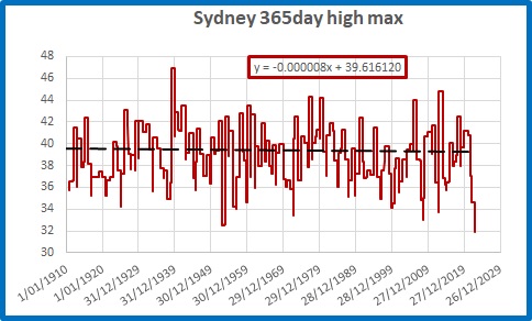
Figure 16: Highest Tmax in 365 day periods

The hottest day was back in 1939, and 2022 had the lowest “hottest day” in a 365 day period on record, with the hottest day being 31.9 degrees.


Figure 17: Lowest Tmax in 365 day periods

Several past winters had cooler maxima.


But is Sydney getting more frequent hot and very hot days?

Figure 18: Running 10 year counts of days over 34.9 degrees

Figure 19: Running 10 year counts of days over 39.9 degrees

The last 10 years have had fewer hot and very hot days than in the past.


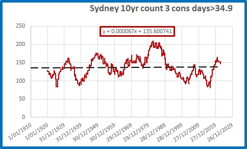
What about heat waves, when there are strings of hot days? The definition appears to have changed, but if we consider three hot days in a row to be a heat wave:


Figure 20: Running 10 year counts of 3 consecutive days over 34.9 degrees

There is a very small trend (0.8 in 100 years) but there were many more 3 day heatwaves in the past.


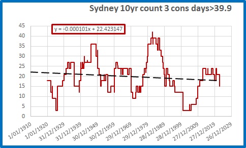
Figure 21: Running 10 year counts of 3 consecutive days over 39.9 degrees

There is a decreasing trend of very hot heat waves (more than 3 less per 100 years), with nearly three times as many 3 day heatwaves of 40 degrees or more in the 10 years to 1982 as in the past 10 years.


Conclusion:


Contrary to popular belief encouraged by politicians and the media, in Australia’s largest city it is clear that:


Rainfall and temperature variability is LOWER than in the past


Droughts are NOT increasing


Extreme rainfall is NOT increasing


Dry years are NOT increasing


Very hot days are DECREASING in frequency


Heatwaves are NOT increasing and are very much LESS COMMON than 40 years ago.


If anything, Sydney’s weather is becoming less extreme and more benign. That should be good news.


We are still waiting for the “projections” of more extreme weather to arrive.

Extreme Weather Events: 2

January 20, 2023

Further to my post yesterday about the Climate Council’s recent fear mongering, with my look at whether the recent flooding at Fitzroy Crossing could be due to increasingly severe rain events, here are two more locations.

I calculate the 10 year running standard deviation of daily rainfall, the 10 year mean, and because the standard deviation must change as the mean changes, I divide the 10 year standard deviation by the 10 year mean.

Early this year there was sever flooding in northern New South Wales. Brays Creek is near Mt Warning about 40 km north of Lismore. Here is the standard deviation divided by average rainfall:

Rainfall over the past 10 years is less extreme than it was 40 to 50 years ago.

The Bruce Highway to north Queensland was blocked for several days, as it normally is every Wet season, by flooding at Goorganga Plains just south of Proserpine. Is rainfall becoming more extreme? Here is the raingauge at Lethebrook, using the same technique.

Nothing exciting to see there either.

Extreme Weather Events: 1

January 19, 2023

Last night On Wednesday night 18 January, the Climate Council released their latest doomsday publication, with the support of Beyond Blue (they’re now off my list of charities to donate to.)

“HIDDEN MENTAL HEALTH TOLL OF WORSENING CLIMATE DISASTERS ON AUSTRALIANS REVEALED WITH NEW NATIONAL POLL”


Climate Councillor, climate scientist at the Australian National University and author of Humanity’s Moment: a Climate Scientist’s Case for Hope, Dr Joelle Gergis said: “The results of this poll are confronting. It’s heartbreaking to realise that many Australians are living with significant levels of distress related to the reality of our changing climate. It shines a light on this invisible mental health crisis that is undermining the stability of our local communities all over the country.

“We need to have a national conversation about climate change adaptation and listen to the experiences of people who have lived through these disasters.

Extreme weather events are going to escalate as our planet continues to warm, so the impacts we have witnessed in recent years are really just the tip of the iceberg. We urgently need to develop plans that protect and support our local communities as climate change-fuelled disasters continue to upend the lives of countless Australians.”

Time for a reality check:

Is there evidence of increasing climate extremes?  Rainfall and temperature are easily measured and data is freely available from the BOM.

First example:  The recent flooding at Fitzroy Crossing. 

A useful measure of extremes is Standard Deviation.  For this technique I am indebted to Willis Eschenbach whose recent post at WattsUpWithThat sparked my interest.

I calculate the 10 year running standard deviation of daily rainfall, the 10 year mean, and because the standard deviation must change as the mean changes, I divide the 10 year standard deviation by the 10 year mean.

The nearest rain gauge with a reasonably long record is Fossil Downs.  Here is the 10 year average daily rainfall:

As you can see average daily rainfall (which nearly all falls in the Wet) has nearly doubled since the decades to the 1960s.

10 year standard deviation:

No wonder people are anxious!  The 10 year figure is very high (but not as high as the 1980s!  Was it more extreme 40 to 50 years ago?)

But here is the standard deviation divided by average rainfall:

This shows that relative to the average, rainfall extremes are actually getting smaller.

Over the next few days I will show rainfall and temperature plots for several Australian cities.  Stay tuned.

Australia’s Energy Future

January 17, 2023

What are the likely prospects for electricity supply in 2023? In a nut shell, much higher prices, but we may avoid blackouts-just.


In April, Liddell coal fired power station will close. Data from OpenNEM shows an extra 2,827 MW of wind and 1,895 MW of solar farm capacity will come on line during the year, and as well rooftop solar will continue to grow rapidly. There will be an extra 154 MW of gas generation at Snapper Point in South Australia. There will be no change to hydro capacity. Figure 1 shows the changes in installed capacity from 2022 to 2023.


Figure 1: Installed Capacity

Across the National Electricity Market, generation and consumption are virtually the same (hydro pumping and battery charging accounts for much less than 1 percent.) Over 24 hours, daily consumption in Gigawatt hours in 2022 is shown in Figure 2.


Figure 2: Daily Electricity Consumption

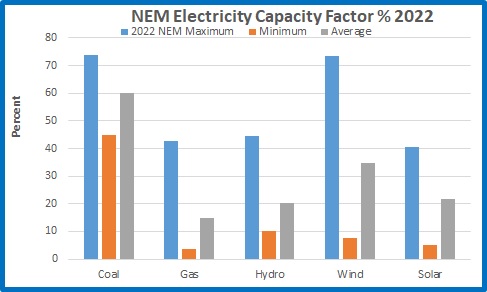
Capacity factor is actual generation as a percentage of installed capacity.


Figure 3: Daily Capacity Factor

Note that in optimum conditions wind has a capacity factor almost as high as coal; low wind results in capacity factor dropping to 7.6 %. On average wind’s capacity factor is 34.9 %. Wind generation varies, and is mostly greater at night.


While there is a massive amount of solar generation each day, depending on cloud conditions, after sundown solar energy is virtually zero. At the early morning and early evening peaks, and all through every night, the amount of daily solar generation is irrelevant, and the nation relies on coal, gas, hydro, and whatever wind is available. When wind energy is very low, fossil fuels and hydro have to increase generation.


In Figure 4, projected consumption for 2023 is calculated from 2022 average capacity factors and 2023 installed capacity.


Figure 4: Projected 2023 Daily Consumption

Assuming there is no increase in demand in 2023- in other words, no population increase, no new electric vehicles or other gadgets, no economic growth- we can directly compare 2022 consumption with 2023. It is likely that the economy will slow, which might be the only thing to save the NEM. Here are three scenarios for 2023 after Liddell closes.


Figure 5: Third Worst Case

If we have a year with winds similar to last, on average there will be 6.8 GWhr less electricity per day. In 2022 there were 197 days when wind generation was below average. Of course, coal, gas, and hydro will easily increase generation to cover this shortfall, but at greater cost than 2022.


But that is the average day. We need to look at hour by hour demand and generation during each day.


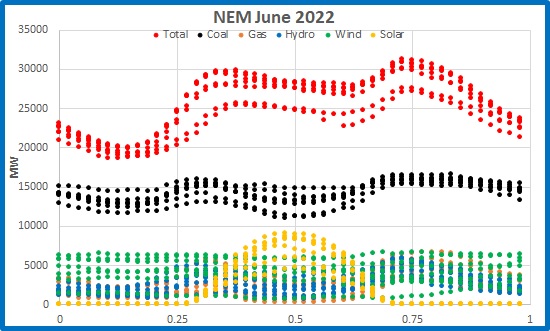
Figure 6 is a plot of electricity supply by source for 30 minute periods for the week of 29 May to 3 June 2022.


Figure 6: Electricity Generation 29 May to 5 June 2022

Battery, biofuel, and diesel generation are not shown as they are tiny. Note the morning and evening peaks, the early morning base of about 19,000 Megawatts, and the daily solar curve, which decreases to virtually zero at local sundown.

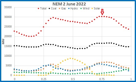
Figure 7 shows the above data just for 2nd June.


Figure 7: Electricity Generation 2 June 2022

I am interested in electricity supply at 6.00 p.m. (the down arrow) as this is close to the daily peak. At 6.00 p.m. solar was irrelevant; and wind generation was extremely low all day- but wind generation can be much lower. In 2022 there were 18 days with less wind generation than that.


What if similar conditions occur in June 2023?


In the next figure I assume identical weather conditions- temperature, cloud, rain, and wind- and use the planned capacity increases for gas and wind, and the decrease for coal, to estimate generation for a similar day in 2023.


Figure 8: Second Worst Case- similar conditions to June 2022

773 MW short. Coal is already at its maximum output for the year. The shortfall can only come from hydro and gas. Gas can generate an extra 320 MW or so to equal the maximum for the year, and of course can go beyond this (theoretically, but impossible, an extra 4,255 MW to maximum installed capacity); hydro can contribute extra (theoretically, but impossible, an extra 3,454 MW to maximum installed capacity) – but there is a physical limit. This will drive prices even higher.


Which brings us to the Worst Case Scenario:


Worst Case: less wind than 2022 at peak times and anything less than maximum coal, gas, and hydro generation.


After April, electricity supply will be tight. If the wind blows strongly enough, we will be able to manage. Wind must be able to produce at least 1,100 MW every hour at peak times. However, the wind is unlikely to co-operate. Therefore, we will have higher prices.


But to avoid blackouts:


Coal generators must produce at or above the 2022 maximum capacity factor, with minimal planned stoppages and no unplanned breakdowns.
Gas generators will have to increase supply- this will of course result in higher prices.
Hydro dams will have to stay full, with no droughts or floods.


Good luck with that.

(Source: OpenNEM)

Flood Disaster at Fitzroy Crossing

January 10, 2023

If you watch the ABC news or listen to Albo, you would think that the flooding in the Kimberley region of WA is “record”, “unprecedented”, and a sign that disasters are becoming more frequent and more severe.

Here’s the ABC:

“The Fitzroy River peaked at a record height of 15.8 metres at Fitzroy Crossing on Wednesday afternoon but is expected to fall below the major flood level of 12.5 metres today.”

Wow! 15.8 metres! How much above the previous record was it, intrepid ABC reporters?

A quick glance at the Fitzroy Crossing Tourism website shows how this flood compares:

YEARLEVEL
198322.37m
198422.28m
198622.09m
199122.39m
199324.38m
199620.40m
199719.80m
199919.00m
200022.05m
200121.85m
200222.66m
200719.20m
200919.90m
201122.69m

Oops!

But we’re getting used to the standard of ABC reporting, and climate catastrophism in general.

h/t Siliggy in a comment at Jen Marohasy’s blog.